Hydrologic Modeling of Katsina-Ala River Basin in Nigeria
Funded by National Space Research and Development Agency, Nigeria
Participant: Rakiya Abdullahi (Research Associate)
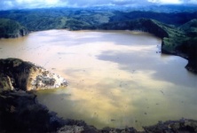
Summary: Lake Nyos in Cameroon is a crater lake formed by volcanic activities at the Oku volcanic field on the Cameroon Volcanic Line. One of the major concerns in the lake is the erosion of the natural dam at the north edge of the lake. If the erosion continues, the dam is likely to collapse and release up to 50 million cubic meters of water, which may lead to severe flooding along downstream in the northwest province of Cameroon and the Nigerian states of Benue and Taraba. Understanding the hydrologic system surrounding the Lake Nyos is of importance for prevention of flooding, conservation of ecological environment, and assessment of socio-economic impact on the civilians in the downstream regions such as the Katsina-Ala in Nigeria. The proposed project will integrate extensive datasets including satellite data, GPS field data, and digital terrain data into a hydrologic model for Katsina-Ala River Basin and its vicinity including the Lake Nyos. ArcHydro will be used to construct a hydrologic database as ‘data models’ and MIKE SHE will be employed to conduct hydrologic simulations. The result of the project will provide comprehensive knowledge of hydrologic system of Katsina-Ala River Basin to mitigate future disasters from a dam failure and manage water resources against such disasters.